Laura: This summer Alex and I ventured all the way to California for one last summer trip...destination: YOSEMITE!!!
Alex:
Get yourself ready for a picture frenzy. It was only a five day trip, with three days in Yosemite itself, but we crammed in a LOT in those three days and got so much more out of it!
 |
| Convertible. Excellent choice. |
Day 1 - Travel
We started by flying to San Francisco in the early morning. Unfortunately we didn't end up having a lot of time to spend here on the way out or the way back, so we'll have to return sometime. We
did get some In-N-Out Burger, and drove across the icy cold bay (it was seriously cold -- the air temperature dropped drastically over the water).
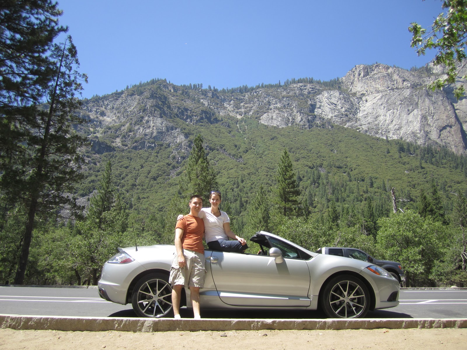
As you can see, we rented a convertible for this trip. This was a really fantastic decision and well worth the extra money to experience the wonderful weather and get a full view of the epic scenery to come. We had the top down almost anywhere we went during the daylight.


We drove east for hours, out of the city, across the bay, over the hills, through the desert, between the orchards, into the hills, and right up to where the hills blurred into the Sierra Nevada mountains.

We arrived at our cozy little bed & breakfast just as it got dark. The Penon Blanco was wonderfully charming. The Innkeeper showed us to our room with its tall bed (probably a good 3 1/2 feet off the ground), super old timey claw-foot bathtub, and home-brewed German beer.
DAY 2
 |
| View from the Penon Blanco |
Breakfast in the morning was candle-lit (even though it was very bright) with fresh fruits, Eggs Benedict, muffins and sweetbreads. As breakfast wrapped up, the innkeeper gave us some maps and sold us some cheap audio CDs for the drive that would give the history of Yosemite, give recommendations of places to stop, good trails to hike, and point out various scenic locations on the drive into Yosemite Valley and during the climb up to Glacier Point.
 |
| Entering Yosemite |

Our first photo stop we found this interesting tree. We didn't know it at the time, but later figured out it was a sequoia.
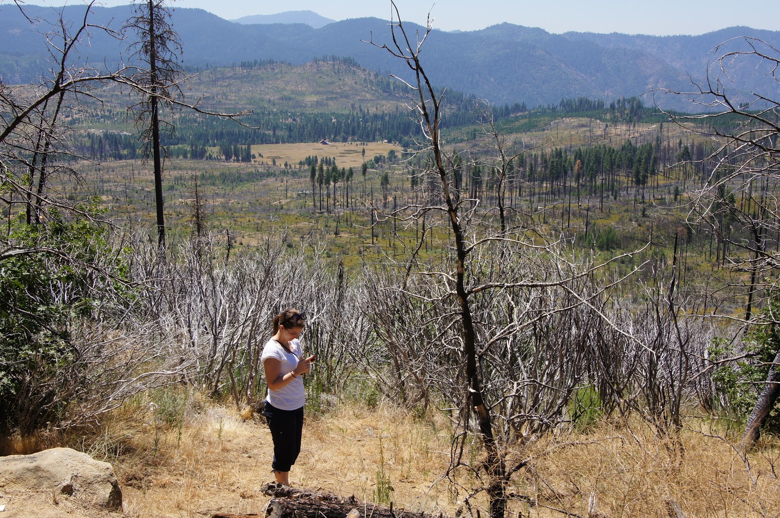
Fire damage made this section of the forest filled with little plant growth, and it was very hot in this area.

As we pulled into the valley we stopped at Bridal Veil falls. This late in the year, there isn't a lot of water, but it still blows around a lot in the wind way up there, which is where the falls gets the name. We trekked up into the rocks to get pretty close to the base of the falls, where there were a number of pools.
Laura: The hike up through the rocks at the base of Bridal Veil falls was really fun! The "path" is basically whatever way you can manage to climb up the giant boulder river rocks in the dried out bed. It was almost like climbing around at Elephant Rock State Park in Missouri. And as Alex mentioned, the reward for climbing to the top was a quick dip into the pools of waterfall/river water in some of the deeper crevice amongst the giant boulders.


We continued our drive into the valley, with massive cliff faces on either side, including El Capitan.

 |
| El Capitan |

 |
| Shooting El Capitan, with Bridal Veil falls in background (I think) |
 |
| One of the meadows along the road |
Once we reached the heart of the valley, we picked a trail to hike. Right near the beginning of the trail we saw a handful of people gathering to look at something just a few feet into the brush.
 |
| RATTLESNAKE!!! |
Since it was a rattlesnake very close to the trail and crawling toward us, I shot a quick pic and decided to let all the other people gathering around to determine the snake's attitude toward humans!


The first real trail we picked was hiking up to see a pair of waterfalls. What we didn't realize was that the trail was practically vertical. (Laura: Wah-wah....)
These shots are partway up, where a bridge ran over the stream. On the right you can see the lower falls in the distance. The higher falls would be well behind that up the mountain.
As we got closer we got a better sense of proportion. In the shot on the right, if you blow it up and look closely at the top of the falls, just to the right of the base of the first tree, there is a white speck just before the rock starts to raise up. That's because there are a couple people standing there looking over the falls, and that's where we were heading. At this point, the trail turns into all stairs. There is a marker at the base of "The Stairs" where people have written their times to reach the top.


At the top of the falls (LEFT & ABOVE), you can look down and see your
vertigo-inducing progress. On the right, you can see other people
coming up the stairs along the rocks on the left.

Behind
the falls is the emerald pool (RIGHT), where some people swim. It looks fun, as
long as you don't float down into the flowing water at the end, which
quickly turns into rapids and goes over the falls.
Assorted wildlife shots below...looks like a
Stellar's Jay in a tree, watching us eat some snacks. A squirrel burrowing under some rocks. A Foof in a tree.


Unfortunately, traveling to high altitudes and then immediately climbing to even higher altitudes is not recommended. I got very light headed and somewhat nauseous about the time we reached the top of the first falls (Laura: And I was pretty darn tired from the wicked stairs). We had also run out of water, so decided to head back down rather than continue to the upper falls. About halfway down I felt much better, so it was definitely the right move.
Here are some nice water-smoothing effects on the falls and the stream under the bridge. The light started fading on the way down, making it easier to get these long exposures.


We took a quick bus ride back to our car, where Half Dome overlooked the parking lot. The setting sun still illuminated the peaks, giving it a sort of glow.

On the way out we spotted some deer, and stopped to see the valley with all the cars driving through.
DAY 3
The first day in Yosemite we spent in the valley. The second day we went up the south side. Here's a shot of the valley, partway up.

We stopped for a quick hike into the woods to see some tucked-away meadows. Here's a tiny cabin along the trail. Many of the trees were covered with a fuzzy looking bright neon yellow moss. It was incredibly quiet and peaceful here.
 |
| Pipe-cleaner Trees! |
We continued driving up toward Glacier point, but stopped for another set of trails.
 |
| Along the road, overlooking the highlands (Yosemite Valley is the other direction) |
The trails we took were to Taft Point and Sentinel Dome. These were great trails, and I absolutely must recommend Sentinel Dome, as it was absolutely amazing to behold. Here's the dome as we approached. Laura is in the distance in red, the dome is still a long ways off.
Laura: The hike up to this dome presents a very intimidating perspective of the hike to come, but this trail was almost a gentle rise compared to the mega stairs we'd done the day before. Also, even if the trail seems steep at points the views from atop this rock are INCREDIBLE! Totally worth the extra energy and time spent exploring this area.
You climb up and around through a section of woods, and then finish up the rocky far side of the dome. Here (RIGHT) we've emerged from the woods, and this little trail of stones marks the final ascent.

At the top, 8117 feet. Not bad - Rochester is about 500ft, so is St Louis... And look, no elevation sickness today!
From the top of Sentinel Dome you have an epic 360 degree view of Yosemite and the Sierra Nevada. I can't begin to describe how awesome and breathtaking it was here. We had lunch here and admired the view for a while before heading back down.


After returning from Sentinel Dome, we continued right past where we had parked our car to see Taft Point. There may have been a faster way, but we didn't decide to do Taft Point for sure until right then. Always wingin' it!
 |
| Chipmunk condo. There was a pile of very white rocks not far from the start of this trail that was crawling with chipmunks. |

The Taft Point trail hikes through the woods for a few miles. There are some dips and winding trails, and then you pop out near Taft Point where the trees suddenly thin out.
Now the thing about Taft point that is one of my most vivid memories from my childhood trip to Yosemite is the fissures (BELOW with some rocks crammed in the crack). These are basically cracks in the rock that are very narrow across and drop over 1000 feet. You can't even see them until you're practically right on top of them because they're so narrow.

The view from Taft Point is great, and you're literally standing on the edge of a drop to thousands of feet below with only a corroded looking bar in front of you. With blowing winds, stone underfoot that has been worn smooth and slick, and a chunk of rock missing under the finicky looking safety railing that has created a steeply angled ramp over the edge, unfortunately I didn't get a lot of great shots from the precipice. Some people were sliding on their bellies up to the edges of some of the other nearby overhangs to get a better look, but I was fine without. Between Sentinel Dome and Glacier Point later, I think I'm okay with that.
Laura: The fissures were really neat! Honestly it was hard to appreciate the severity of the drop from this area until we went to the very edge with the single area of metal-tube hand rail. Now THAT was a drop-off!
Speaking of, Glacier point was our next and final stop for the day. The view is amazing, of course! Where Sentinel Dome has a spectacular 360 degree view, Glacier point gives more of an edge view where you can see down into the valley.

On the right, toward the bottom-center you can see the falls we climbed the previous day, with the emerald pool behind it. Just to the right of center is the upper falls that we didn't quite reach.

After another long day of hiking, we headed south to the Hounds Tooth Inn in Oakhurst - our next B&B. We hated to leave the nice cozy atmosphere at Penon Blanco, but this way we'd be a little closer for where we would be going the next day...
 |
| Hiking is dirty business. Those aren't tan lines! |
DAY 4
The last day that we would spend in Yosemite was at the Mariposa Grove, where a number of giant Sequoia grow. It was a serious challenge trying to shoot pictures of these massive trees and really show their immense scale!
 |
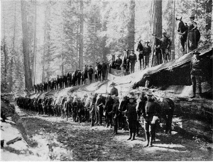
| It was much easier to take pictures of trees that had fallen down |
These trees are hundreds and even over a thousand years old. They even last for ages after they've fallen. The tree in the shot above (Fallen Monarch) had been down for over a hundred years. The plaque on the plaque shows a picture of a
cavalry troop perched on and around the tree.
 |
| The first branch on the right is 7' diameter |
The behemoth to the right is one of the oldest trees, the Grizzly Giant, at 2700 years.
 |
| California Tunnel tree |
As we headed further into the grove and started climbing into the hills, the crowds quickly thinned.
 |
| Telescope tree. Hollowed out by fire, but still alive |
 |
| Beautiful little grove with several big trees. A couple people appear as shadows in the lower right. |

 |
| Pic-a-Foof! |


 |
| This is actually a Sugar Pine cone. The Sequoia cones are about the size of a medium chicken egg |
 |
| Hiking is risky business!! |

 |
| The 2-room cabin tucked away here acts as a little museum and info center |

 |
| Pit stop! |


 As we got closer we got a better sense of proportion. In the shot on the right, if you blow it up and look closely at the top of the falls, just to the right of the base of the first tree, there is a white speck just before the rock starts to raise up. That's because there are a couple people standing there looking over the falls, and that's where we were heading. At this point, the trail turns into all stairs. There is a marker at the base of "The Stairs" where people have written their times to reach the top.
 At the top of the falls (LEFT & ABOVE), you can look down and see your
vertigo-inducing progress. On the right, you can see other people
coming up the stairs along the rocks on the left.
At the top of the falls (LEFT & ABOVE), you can look down and see your
vertigo-inducing progress. On the right, you can see other people
coming up the stairs along the rocks on the left.


 Here are some nice water-smoothing effects on the falls and the stream under the bridge. The light started fading on the way down, making it easier to get these long exposures.


 The last day that we would spend in Yosemite was at the Mariposa Grove, where a number of giant Sequoia grow. It was a serious challenge trying to shoot pictures of these massive trees and really show their immense scale!


 We drove east for hours, out of the city, across the bay, over the hills, through the desert, between the orchards, into the hills, and right up to where the hills blurred into the Sierra Nevada mountains.


 We stopped for a quick hike into the woods to see some tucked-away meadows. Here's a tiny cabin along the trail. Many of the trees were covered with a fuzzy looking bright neon yellow moss. It was incredibly quiet and peaceful here.


 The Taft Point trail hikes through the woods for a few miles. There are some dips and winding trails, and then you pop out near Taft Point where the trees suddenly thin out.


